Sanborn Insurance Maps for The Dalles, Oregon in Wasco County
What are the Sanborn Maps?
Sanborn Maps is an American publisher of historical and current maps of US cities and towns that were initially created to estimate fire insurance liabilities. The company’s maps are frequently used for preservation and restoration efforts as well as history research.
The Sanborn maps themselves are large-scale lithographed street plans at a scale of 50 feet to one inch (1:600) on 21 by 25 inches (53 by 64 cm) sheets of paper. The maps were created in volumes, bound and then updated until the subsequent volume was produced. Larger cities would have multiple volumes. In between volumes, updates (new drawings of new or altered buildings or lots) were created and sent out to be pasted on top of the old maps (referred to as ‘slips’) to reduce expense and preserve accuracy.
The volumes contain an enormous amount of information. They are organized as follows: a decorative title page, an index of streets and addresses, a ‘specials’ index with the names of churches, schools, businesses etc., and a master index indicating the entirety of the mapped area and the sheet numbers for each large-scale map (usually depicting four to six blocks) and general information such as population, economy and prevailing wind direction.
The maps include outlines of each building and outbuilding, the location of windows and doors, street names, street and sidewalk widths, property boundaries, fire walls, natural features (rivers, canals, etc.), railroad corridors, building use (sometimes even particular room uses), house and block number, as well as the composition of building materials including the framing, flooring, and roofing materials, the strength of the local fire department, indications of sprinkler systems, locations of fire hydrants, location of water and gas mains and even the names of most public buildings, churches and companies.
Source: http://en.wikipedia.org/wiki/Sanborn_Maps
Sanborn Maps 1884 – 1960
The following are a list of the Sanborn Insurance Maps available for The Dalles, Wasco County, Oregon. To view the PDF documents, left-click on the link. Note the artwork of the stamp contains additional information.
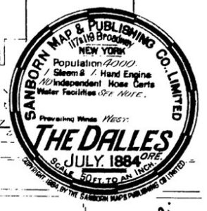 1884 – July
The Dalles, Oregon
Wasco County
The Dalles 1884 July, Section C, 01
The Dalles 1884 July, Section C, 02
The Dalles 1884 July, Section C, 03
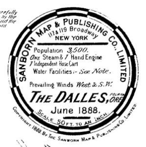
1888 – June to 1889 – May
The Dalles, Oregon
Wasco County
The Dalles 1888 June, 1889 – May, Section C, 01
The Dalles 1888 June, 1889 – May, Section C, 02
The Dalles 1888 June, 1889 – May, Section C, 03
The Dalles 1888 June, 1889 – May, Section C, 04
The Dalles 1888 June, 1889 – May, Section C, 05
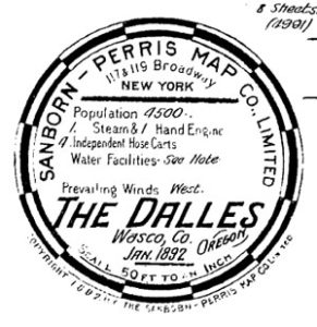
1892 – January
The Dalles, Oregon
Wasco County
The Dalles 1892 January, Section C, 01
The Dalles 1892 January, Section C, 02
The Dalles 1892 January, Section C, 03
The Dalles 1892 January, Section C, 04
The Dalles 1892 January, Section C, 05
The Dalles 1892 January, Section C, 06
The Dalles 1892 January, Section C, 07
The Dalles 1892 January, Section C, 08
1900 – November
The Dalles, Oregon
Wasco County
The Dalles, 1900 November, Section C, 01
The Dalles, 1900 November, Section C, 02
The Dalles, 1900 November, Section C, 03
The Dalles, 1900 November, Section C, 04
The Dalles, 1900 November, Section C, 05
The Dalles, 1900 November, Section C, 06
The Dalles, 1900 November, Section C, 07
The Dalles, 1900 November, Section C, 08
The Dalles, 1900 November, Section C, 09
The Dalles, 1900 November, Section C, 10
The Dalles, 1900 November, Section C, 11
The Dalles, 1900 November, Section C, 12
The Dalles, 1900 November, Section C, 13
The Dalles, 1900 November, Section C, 14
The Dalles, 1900 November, Section C, 15
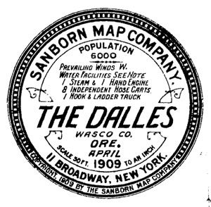
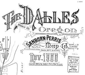
1909 – April
The Dalles, Oregon
Wasco County
The Dalles, 1909 April, Section C, 01
The Dalles, 1909 April, Section C, 02
The Dalles, 1909 April, Section C, 03
The Dalles, 1909 April, Section C, 04
The Dalles, 1909 April, Section C, 05
The Dalles, 1909 April, Section C, 06
The Dalles, 1909 April, Section C, 07
The Dalles, 1909 April, Section C, 08
The Dalles, 1909 April, Section C, 09
The Dalles, 1909 April, Section C, 10
The Dalles, 1909 April, Section C, 11
The Dalles, 1909 April, Section C, 12
The Dalles, 1909 April, Section C, 13
The Dalles, 1909 April, Section C, 14
The Dalles, 1909 April, Section C, 15
The Dalles, 1909 April, Section C, 16
The Dalles, 1909 April, Section C, 17
The Dalles, 1909 April, Section C, 18
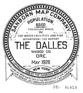
1926 – May
The Dalles, Oregon
Wasco County
The Dalles, 1926 May, Section C, 01
The Dalles, 1926 May, Section C, 02
The Dalles, 1926 May, Section C, 03
The Dalles, 1926 May, Section C, 04
The Dalles, 1926 May, Section C, 05
The Dalles, 1926 May, Section C, 06
The Dalles, 1926 May, Section C, 07
The Dalles, 1926 May, Section C, 08
The Dalles, 1926 May, Section C, 09
The Dalles, 1926 May, Section C, 10
The Dalles, 1926 May, Section C, 11
The Dalles, 1926 May, Section C, 12
The Dalles, 1926 May, Section C, 13
The Dalles, 1926 May, Section C, 14
The Dalles, 1926 May, Section C, 15
The Dalles, 1926 May, Section C, 16
The Dalles, 1926 May, Section C, 17
The Dalles, 1926 May, Section C, 18
The Dalles, 1926 May, Section C, 19
The Dalles, 1926 May, Section C, 20
The Dalles, 1926 May, Section C, 21
The Dalles, 1926 May, Section C, 22
1926 – May to 1960 – September
The Dalles, Oregon
Wasco County
Updated and reindexed
The Dalles, 1926 May-1960 Sept., Section C, 01
The Dalles, 1926 May-1960 Sept., Section C, 01a
The Dalles, 1926 May-1960 Sept., Section C, 02
The Dalles, 1926 May-1960 Sept., Section C, 03
The Dalles, 1926 May-1960 Sept., Section C, 04
The Dalles, 1926 May-1960 Sept., Section C, 05
The Dalles, 1926 May-1960 Sept., Section C, 06
The Dalles, 1926 May-1960 Sept., Section C, 07
The Dalles, 1926 May-1960 Sept., Section C, 08
The Dalles, 1926 May-1960 Sept., Section C, 09
The Dalles, 1926 May-1960 Sept., Section C, 10
The Dalles, 1926 May-1960 Sept., Section C, 11
The Dalles, 1926 May-1960 Sept., Section C, 12
The Dalles, 1926 May-1960 Sept., Section C, 13
The Dalles, 1926 May-1960 Sept., Section C, 14
The Dalles, 1926 May-1960 Sept., Section C, 15
The Dalles, 1926 May-1960 Sept., Section C, 16
The Dalles, 1926 May-1960 Sept., Section C, 17
The Dalles, 1926 May-1960 Sept., Section C, 18
The Dalles, 1926 May-1960 Sept., Section C, 19
The Dalles, 1926 May-1960 Sept., Section C, 20
The Dalles, 1926 May-1960 Sept., Section C, 21
The Dalles, 1926 May-1960 Sept., Section C, 22
The Dalles, 1926 May-1960 Sept., Section C, 23
The Dalles, 1926 May-1960 Sept., Section C, 24
Additional Resources
For more information about city maps of The Dalles, Oregon, contact the City of The Dalles Planning Office, Landmarks Committee:
The Dalles City Hall
313 Court Street
The Dalles, Oregon 97058
Phone: 541-296-5481
For information on Wasco County maps, contact the Wasco County Planning Department:
Wasco County Planning Department
2705 E. 2nd St.
The Dalles, OR 97058
Phone: 541-506-2560
http://www.co.wasco.or.us/planning
Email: [email protected]
For additional Sanborn maps from other states, visit the Library of Congress website at:
http://www.loc.gov/rr/geogmap/sanborn/