Columbia Gorge Scenic Waterfalls
Update 2019 – Please be arare the descriptions below were written prior to 2017. For those who missed the news, the Columbia Gorge experienced a catastrophic wildfire – the Eagle Creek fire – that began September 5, 2017 and is, in some locations, still smoldering. Access to the waterfall area, including the Historic Columbia River Highway, was completely shut down for months, and is being re-opened gradually, as safety allows. The US Forest Service and Oregon Department of Transportation have made heroic efforts to clear debris, protect the public and reopen access to our beloved waterfalls area. You are urged to treat closure and warning signs as if your life depended on it; which it does. We don’t want to see your name on the front page of the local news with the caption, “Stubborn hiker ignored closure signs and died when unstable trail collapsed in a landslide.” When these areas are reopened, it will be posted. Please obey all signs for your safety.
The Columbia River Gorge Scenic Area is famous for its waterfalls – 77 on the Oregon side alone! They come in all shapes and sizes. They can be classified into eight forms: plunge, horesetail, fan, cascade, punchbowl, block, tier, and segmented.
You can see examples of each of these waterfall shapes on a tour of the Historic Columbia River Highway (Highway 30). Be prepared to do a lot of stopping and starting again – these spectacular waterfalls are all within approximately a 15 mile distance of each other!
Directions
You can get there from Oregon’s interstate – I-84. If you’re coming from the west, you can exit at Troutdale (Exit 17), Lewis and Clark State Park (Exit 18), Corbett (Exit 22), Bridal Veil (Exit 28 or Dodson (Exit 35). If you’re coming from the east, you can exit at Ainsworth/Dodson [Exit 35], Bridal Veil [Exit 28] or Corbett (Exit 22]. Access if you park at Multnomah Falls from I-84 will be by foot, only, but if you take the scenic Highwy 30, you’ll be able to drive the whole stretch.

Historic Columbia River Highway
The Historic Columbia River Highway, (aka Highway 30) is a lovely trip all unto itself. The intent of the builders, Sam Hill, Simon Benson, was to build a good road artfully woven in with the landscape. And what a spectacular job they did! For more information about the Columbia River Gorge Scenic Highway, visit the Friends of the Historic Columbia River Highway website at: http://www.hcrh.org/
Parking & Accessibility
Many trailheads are now designated Trail Parks. The Northwest Forest Pass Program requires a day pass or season permit to park near designated trailheads. The fees from these permits go directly to maintaining and improving the trails, land and facilities we all enjoy. You can obtain a pass by calling 1-800-270-7504, or purchase online. Motorcycle passes are also available.
Warning: Most of the hiking trails that lead to the waterfalls are steep slopes that are not wheelchair accessible. However, several of the waterfalls can be easily viewed from the highway, including Horsetail Falls, Multnomah Falls, Shepperds Dell Falls and Wahkeena Falls. Others may require only a minimal of assistance to reach a viewing location. If you follow the Columbia River Highway (Hwy 30) west, you will come to the historic Vista House at Crown Point State Park. This historic building on the Historic Columbia River Highway provides a gorgeous panorama of the Columbia River Gorge.
Horsetail Falls
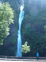
Horsetail Falls Trail (FS #438) off the Historic Columbia River Highway is a great place to start your Gorge Waterfall Tour. Pass through a chamber behind Ponytail Falls, then continue on Oneonta Gorge Trail to see Oneonta Gorge, Oneonta Falls and Triple Falls.
Horsetail Falls
Type: horsetail
Height: 176 feet
Access: car or hiking
This classic example of a horsetail formation along Horsetail Creek can be viewed from a turnout on the Historic Highway, 2.5 miles east of Multnomah Falls.
Triple Falls
Type: segmented
Height: 100-135 feet
Access: hiking
The Triple Falls viewpoint is on Oneonta Trail #424, 1.7 miles from its trailhead. The trailhead is 0.8 miles past the junction with Horsetail Falls Trail #438. The Horsetail Falls trailhead is 2.5 miles east of Multnomah Falls on Historic Highway. Triple Falls plunges along Oneonta Creek. It is of triplet form, not triple as the name implies.
Oneonta Gorge
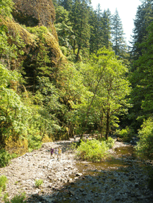
Oneonta Gorge is a cool mossy canyon with a unique botanical area. The Oneonta Trail (FS Trail #424) follows this skinny gorge to its falls and beyond, joining other trails for loop hikes. The waterfall can only be seen from hiking inside the gorge.
If you choose to hike Oneonta Gorge, do so at your own risk. Storms in the late 1990’s washed fallen trees downstream, creating a large log jam near the mouth of the gorge. Climbing over the log jam to access the deeper parts of the gorge should only be done at your own risk, with the understanding that nature is precarious at best.
Hiking inside the gorge means walking over large river rocks and wading through the cold creek. Wear sturdy shoes and be prepared to get wet. The hike is often best on a hot summer day.
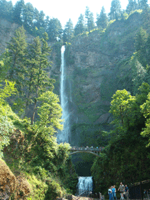
Multnomah Falls
Multnomah Falls is the most visited natural attraction in Oregon. Over 2.5 million visitors a year come from every part of the world to view the lush foliage, tall firs, and towering cliffs that form the spectacular backdrop to the second highest year-round waterfall in the United States. Multnomah Falls is the highest waterfall in the Columbia River Gorge with a total drop of 620 feet.
A steep paved trail leads visitors to a platform above the falls. The waterfall is visually complimented by Benson Bridge, built in 1914 by Italian stone masons, and Multnomah Falls Lodge built in 1925. Inside the Lodge is a gift shop, restaurant, and U.S. Forest Service Information Center.
Major improvements were made in 1994 to the lodge, including access for those with disabilities, enlarging the outdoor dining terrace, improving and relocating the restrooms and snack bar and adding a fully-appointed interpretive information Visitor’s Center.
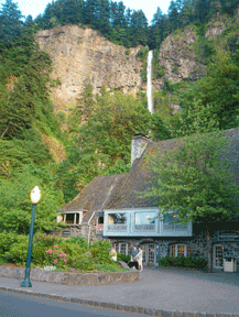
Multnomah Falls Lodge
Lumber baron, Simon Benson, an avid philanthropist, donated funds for the land encompassing Multnomah Falls and for the 1914 construction of the Benson Bridge, which spans the chasm above the lower falls. Multnomah Falls park was dedicated in 1915.
Ten years later Multnomah Falls Lodge, now a National Historic Landmark, was constructed at a cost of $40,000. The stone and timber “Cascadian” style building was designed by noted Portland architect Albert Doyle. In 1939 the city of Portland transferred ownership of the park and lodge to the US Government. The US Forest Service has administered the site since then.
Multnomah Falls Lodge was threatened by a wildfire in the 1990’s and most recently in 2017. You can still see the nearby husks of burned trees where the blaze came to within feet of this historic building. Steep cliffs and difficult terrain made the fire hard to battle, but firefighters, using helicopters with 1000 gallon buckets to dip water out of the Columbia River, were able to douse the blaze and save the lodge.
Rapid uplift of this region over the last two million years has forced the Columbia River to incise the Gorge as seen today. However side streams, like Multnomah Creek, did not have the erosive power of the Columbia River and were left behind to plunge off the Gorge’s basalt cliffs. Multnomah Falls is a “side-effect” of the geologic origin of the Gorge.
While the spectacular geology of Multnomah Falls appears timeless, the rockface is continually being worn away by the force of the waterflow. This fact was highlighted on Labor Day, September 4, 1995, when a large rock slid from the face of upper Multnomah Falls due to the natural process of erosion and dropped into the upper plunge pool. The spot where this 400 ton boulder broke off is easily identifiable as a flat, tan colored area where the water is splashing on the rock (during times of low water flow). It fell 225 feet and created a splash of 70 feet, spewing water and small rocks that flew over the Benson bridge. A wedding party just happened to be on the bridge for photos when the boulder fell. 20 people had minor injuries from flying, gravel size rock chips, including the groom who was struck by flying rock in a particularly delicate part of his anatomy. His bride reported the next day in The Oregonian that, despite his injuries, he had still been able to bravely perform his conjugal duties.
Wahkeena Falls
This 242 foot falls was once known as Gordon Falls in honor of pioneer land-owner F.E. Gordon. In 1915, a committee of the Mazamas changed the name of the creek and falls to Wahkeena – the Yakama Indian word for “most beautiful.”
Wahkeena Trail climbs to 900 feet for a spectacular view of the Columbia River, described by Rudyard Kippling as “penned between gigantic stone walls crowned with the ruined bastions of Oriental palaces.” Traveling among rocks festooned with deer fern, the trail follows the creek close to its source and enters a steep forest of moss-hung vine maple, sword fern, and 200-ft Douglas firs to end at Larch Mountain Trail in 2.8 miles. Wahkeena Trail connects with several other trails enroute and allows many loop possibilities. Wahkeena Falls Picnic Area provides a picnic shelter and a stone fireplace.
Wahkeena Creek is isolated and unique. Without a network of tributary streams flowing from higher elevations, Wahkeena Creek is isolated from adjacent watersheds. This isolation has created a unique habitat for 8 species of aquatic insects that are only found in the Columbia River Gorge. No other watershed in the Pacific Northwest can yet claim this many endemic species. Two of these insects, the Wahkeena flightless stonefly (Nemoura wahkeena) and Anderson’s caddisfly (Neothremma andersoni) are only found in the Wahkeena watershed.
Wahkeena Falls
Type: tiered
Height: 242 feet
Access: car or hiking
This fall along Wahkeena Creek can be seen from the Wahkeena picnic area across the Historic Highway. There are parking spaces at the picnic area. It is 0.5 miles west of Multnomah Falls. The Yakama Tribe word “wahkeena” means “most beautiful.”
Fairy Falls
Type: fan
Height: 20-30 feet
Access: hiking
This waterfall along Wahkeena Creek is 1.1 miles up from the trailhead of Wahkeena Trail #420. You can access this trailhead at Wahkeena Falls, which is 0.5 miles west of Multnomah Falls on the Historic Highway.
Latourell Falls
At Latourell Falls you can see entablature jointing. This is a distinctive jointing pattern found in the Columbia River basalt flows. Stress, produced when lava cools and contracts, causes joints to form. Columnar joints (colonnades) are found below the entablature. The were formed perpendicular to the lower cooling surface and are beautiful prisms and columns. You can also see such jointing at Shepperds Dell, Crown Point and Multnomah Falls.
Latourell Falls
Type: plunge
Height: 249 feet
Access: car or hike
In Guy W. Talbot State Park, this fall of Latourell Creek is named after Joseph Latourell, a prominent Columbia River Gorge settler. It is on the Historic Highway, 3.4 miles west of Exit 28 off I-84. It’s a short walk to the viewpoint from the park’s picnic area to the viewpoint.
Upper Latourell Falls
Type: plunge
Height: 75-100 feet
Access: hiking
This is 0.8 miles along the trail from Latourell Falls (above). You can get to both falls from the Historic Highway, 3.4 miles west of Exit 28 off I-84. It is possible to walk behind the falling water.
Sheppards Dell
Sheppards Dell Falls
The view from the top of the trail descending into Sheppers Dell is positively dizzying. This trail, nestled into the crevices and crags of the Columbia Gorge, is a narrow pathway.
Sheppards Dell Rock Formation and Sheppards Dell Falls
Type: tiered
Height: upper falls 35-50 feet; lower falls 40-60 feet
Access: car or hiking
The two tiers of this falls can be seen from the bridge crossing at Sheppards Dell State Park, two miles west on the Historic Highway from Exit 28 off I-84. The lower falls is a horsetail formation and the upper falls is a plunge formation.
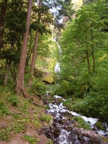
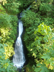
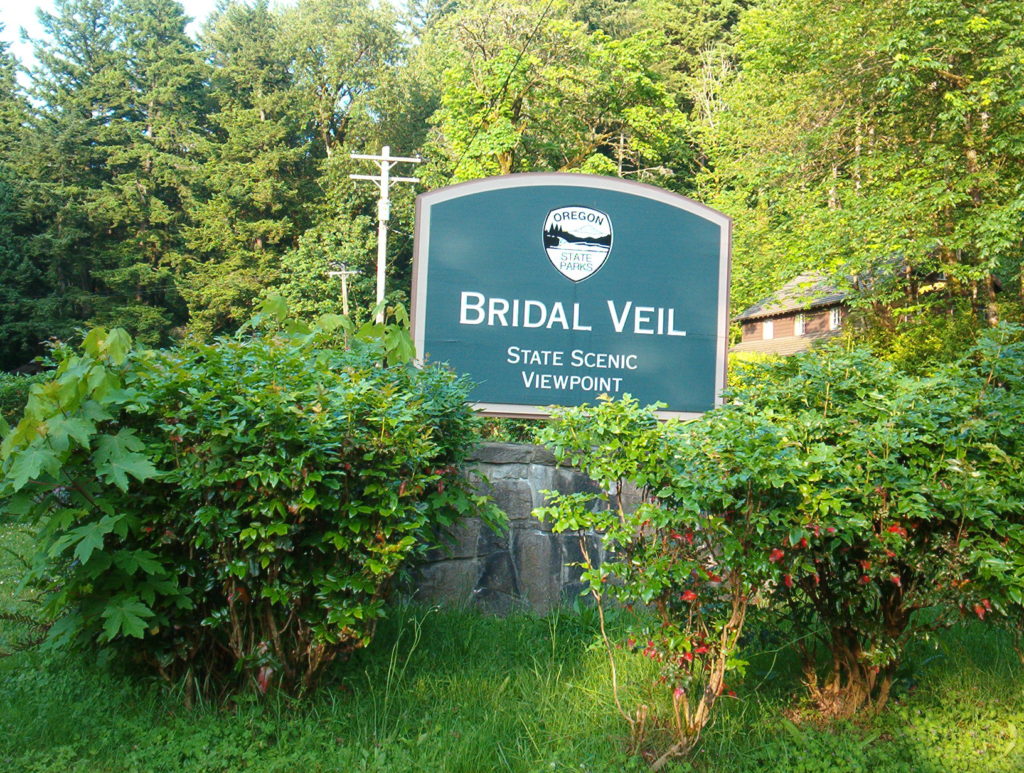
Bridal Veil Falls
The parking lot for Bridal Veil Falls is directly across from the Bridal Veil Lodge, a bed and breakfast for weary waterfall watchers. Bridal Veil Falls can be seen from Interstate 84, but if you want to see it while on your Historic Highway Waterfall Tour, you’ll have to park the car and walk the 2.2 miles round trip.
Bridal Veil Falls
Type: tiered
Height: upper falls: 60-100 feet; lower falls 40-60 feet
Access: car or hiking
Bridal Veil Creek abruptly drops twice. The parking area for this falls is about one mile west of Exit 28 off I-84. A short trail winds down to the base of the lower tier. Along the pathway, look across the Columbia River towards views of seasonal falls on the Washington side of the Gorge.
Tanner Creek and Eagle Creek Area
NOTE: Be aware the Eagle Creek Area is where the 2017 wildfire began, and that area received some of the most severe damage. Eagle Creek trail is still closed at this time.
Wahclella Falls
Type: tiered
Height: upper 15-25 feet; lower 50-70 feet
Access: hiking
This thunderous waterfall is in the Tanner Creek area. To get there, turn off I-84 at Bonneville Dam (Exit 40) and proceed south several hundred yards to the Tanner Creek Trail parking area. Start at the trailhead and hike 0.5 mile to the trail’s end at the falls. East Fork Falls can also be seen streaming above the descent from a vantage on the west side of Tanner Creek.
Metlako Falls
Type: plunge
Height: 100-150 feet
Access: hiking
The viewpoint is 1.5 miles from the trailhead of Eagle Creek Trail #440 on Eagle Creek Park. If you’re coming from the west on I-84, take Exit 41. If you’re coming from the east, you’ll make a U-turn: take I-84 west, exit at Exit 40, go on I-84 East and take Exit 41. The waterfall was named in 1915 after the legendary Indian goddess of salmon.
Punch Bowl Falls
Type: punch bowl
Height: 10-15 feet
Access: hiking
Punch Bowl Falls may sound short but it is exquisite and is a classic example of a punchbowl formation. Like Metlako Falls, it is also at Eagle Creek Park. If you’re coming from the west on I-84, take Exit 41. If you’re coming from the east, you’ll make a U-turn: take I-84 west, exit at Exit 40, go on I-84 East and take Exit 41. Hike 2.1 miles from the trailhead of Eagle Creek Trail #440 (0.6 mile past Metlako Falls viewpoint) to a short side trial leading to the falls.
Washington Waterfalls
Most waterfalls are limited to the Oregon side of the Columbia River Gorge because landslides modify the steepness on the Washington side. The entire region’s bedrock material is tilted slightly southward. When it is water saturated, the upper basaltic layers on the north side of the river slide into the Gorge. Thus, waterfalls on the Washington side are fewer and smaller.
But mentioned here is a fall complemented by 600-foot geologic projection, Beacon Rock.
Beacon Rock
Beacon Rock is adjacent to State Route 14, Washington State’s main highway along the Columbia River. To get to the Beacon Rock area from I-84, take Exit 44 Cascade Locks and cross Bridge of the Gods over the Columbia River to Washington State. Take S.R. 14 westward for 7 miles until you are greeted by the impressive Beacon Rock.
Hardy Falls
Type: horsetail
Height: 80-120 feet
Access: hiking
Turn north off S.R. 14 onto the spur road across from Beacon Rock. Drive 0.3 miles to the picnic area and the trailhead of Hamilton Mountain Trial. After a moderate climb of about 1.25 miles, reach two short spur paths. The upper path to the far right leads to a viewpoint overlooking the drop along Hardy Creek.
Source:
• Text from Gorge Vistas: A visitor’s guide to National Forest recreation opportunities in the Columbia River Gorge, Forest Service Pacific Northwest Region and US Dept. of Agriculture.
• Friends of Multnomah Falls Membership Brochure, PO Box 426, Troutdale, OR 97060, 503-253-0590.
• For additional hiking information, the best hiking guide book is Curious Gorge, by Scott Cook
Updates on Mt. Hood National Forest and the Eagle Creek Fire area closures: https://www.fs.usda.gov/mthood