|
| |
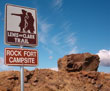 |
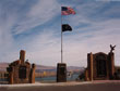
Rock Fort |
| |
|
|
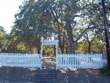
Rock Fort
Lewis & Clark Historic Camp Site (1805-06)
West of Union Street Portal along the Columbia River Promenade, part of the Riverfront Trail. Located on 1st Street between Union Street (downtown) and W. Webber.
Here Lewis & Clark and the Corps of Discovery camped on both legs of their journey; October 1805, and again in April 1806. They called this site at the mouth of “Que-neet Creek,” or Fort Rock Camp. Memorial plaque and interpretive signage located on site.
Riverfront Trail: Rock Fort is located along the Lewis and Clark Riverfront Trail. This 9-1/2 mile trail includes interpretive signage and provides a pedestrian/bike path along the banks of the Columbia River accessing areas such as Taylor Lakes, The Dalles Port, Rock Fort (Lewis and Clark Campsite), The Dalles Marina, Riverfront Park. You can access the train from the Discovery Center, Klint's Drive, Union Street Underpass, or the Marina. Operated by Northern Wasco County Park and Recreation District. (541) 296-2072.. |
 |
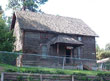
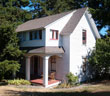
Fort Dalles Surgeon's Quarters |
| |
|
|
Fort Dalles Museum Surgeon's Quarters (1856)
500 West 15th and Garrison Street
(541) 296-4547
The site was first occupied in 1850 and was called Camp Drum. In 1853 the name was changed to Fort Dalles. By the late 1850's the Indian frontier had moved east and after temporary use in 1867-68 there was no longer a need for a fort in The Dalles. The Fort Dalles Museum, Oregon's oldest history museum, was established by the Sorosis Society and has been in operation since 1905 preserving the historic Fort Dalles site. The original Surgeon’s Quarters is the fort’s last surviving building, the other buildings having burned. Pioneer and military artifacts from 1860s, antique vehicles are on display including the Umatilla House bus and the original 'mudcoach' or mail coach that used to travel between Canyon City and The Dalles.
 Download PDF Download PDF
National Registry of Historic Places
|
 |
Anderson Homestead |
| |
|
|
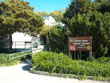
Anderson Homestead (1895)
West 16th and Garrison Street
Visitors are also able to tour the Anderson Farm House, a hand-hewn wooden homestead crafted by Swedish immigrants. An adjacent granary and barn are part of the homestead. Anderson Farmhouse is part of the Fort Dalles Museum collection, and is located across the street from the Fort on West 16th St between Garrison and Trevitt. Both sites are National Historic Landmarks.
|
|
Rorick House (Moody House, circa 1850)
300 West 13th Street
(541) 296-1867
The oldest home in The Dalles was built by a non-commissioned Army officer stationed at Fort Dalles. As part of the Fort Dalles Miltary Reservation, the house served as the Sergeant’s Quarters. Former Mayor of The Dalles and U.S. Congressman (1899 to 1903) Malcolm A. Moody owned the house from 1884 until his death in 1925. The house was purchased and owned by Eck and Mae Rorick. Now owned and operated by the Wasco County Historical Society as a museum.
History of the Rorick House (Moody House)
|
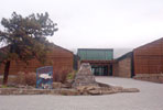 |
Columbia Gorge Discovery Center and Wasco County Historical Museum |
|
Columbia Gorge Discovery Center and Wasco County Historical Museum
5000 Discovery Drive
West on W. 6th Street (Hwy 30)
(541) 296-8600
West on W. 6th Street (Hwy 30). Entrance across from golf course. 5000 Discovery Drive.
Regional interpretive center for the Columbia River Gorge National Scenic Area. Focus on natural history, the Missoula Ice Age Floods, Native American history and pioneer development. Explore the Columbia River Gorge from its beginnings 40 million years ago until today.
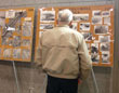
The Discovery Center also houses the photo collection of the Wasco County Pioneer Association, a collection of over 3000 historic photographs taken in The Dalles and the Mid Columbia/Columbia River Gorge. The Pioneer Association holds its annual meeting the first Saturday of May, giving the public an opportunity to view these historic photos. http://www.wascopioneers.org/
|
|
Wasco County Pioneer Association
The Association is a non-profit Oregon corporation; membership is open to anyone with an interest in early-Oregon history. The annual meeting is held in The Dalles on the first Saturday in May. The photos are now on display at the Columbia Gorge Discovery Center.
http://www.wascopioneers.org/ |
 |
The Dalles Wasco Co. Library |
|
The Dalles-Wasco County Public Library
722 Court Street
(541) 296-2815
The public library in Wasco County was established in 1910. The "new" library was built in the 1960's to replace the cramped quarters at the Carnegie Library building (see The Dalles Art Center.) The library houses a microfilm collection of all the available newspapers printed by The Dalles Chronicle, and its predecessor, The Dalles Mountaineer. The rare bookcase contains original journals and books published by The Dalles authors, as well as many volumes covering local and Pacific Northwest history. The ever-patient librarians often help long-distance genealogists and history buffs.
|
 |
Pioneer Cemetary |
|
Pioneer Cemetery (1860)
400 Block East Scenic Drive
Lat: 45°35.27N, Lon: 121°11.10W
The original name was City Graveyard, or Pioneer City Graveyard. It was sometimes referred to as the Bigelow graveyard. On June 14, 1860 W.D. Bigelow donated 2.12 acres of land for use as a cemetery by pioneer families, with the first burial shortly thereafter. This graveyard was used instead of the Indian Mission cemetery (16th Street between Garrison and Pentland streets) after 1860. Earliest burials were Michael J. Kelly (died May 29, 1860) and James Tivis (died July 22, 1860). There are 228 graves (some unmarked), including that of Judge Joseph Gardner Wilson (1826-1873). The Pioneer Cemetery is administered by the City of The Dalles and the Historic Landmarks Commission. The Wasco County Genealogical Society dedicated a monument listing the names of those who have been buried in this cemetery on Memorial Day, May 31, 2010.
|
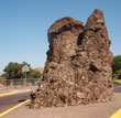 |
Pulpit Rock |
|
Pulpit Rock (1838)
East 12th and Court Streets
During the period between 1838 and 1848, Pulpit Rock is said to have been a preaching location for the Wascopam Methodist mission in the area, founded by Rev. Jason and Daniel Lee, and H.W. Perkins. Jason Lee made repeated trips between Oregon and the east coast, speaking to the public about the importance of the Oregon Territory. His passion and eloquence drew a great deal of attention to Oregon and triggered the mass emmigration on the Oregon Trail.
|
| |
|
|
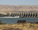
The Dalles Dam (1957)
The Dalles Dam - Built and operated by the U.S. Army Corps of Engineers, The Dalles Lock and Dam is one of the largest hydropower producing dams in the United States, and extends 1.5 miles across the Columbia River. Powerhouse capacity is 1.8 million kilowatts. Since 1957, The Dalles Dam has provided the Pacific Northwest with a reliable water source for navigation, irrigation, flood mitigation, and recreation. Want to take a tour? Call or stop by The Dalles Dam Visitor Center for an up to date tour schedule (541) 296-9778.
|
| |
The Dalles Dam Visitor Center
3545 Bret Clodfelter Way
(541) 296-9778
Directions:
Located at Seufert Park on the Oregon shore. Take The Dalles Bridge Junction exit 87 off I-84.
Open: Seven days a week from 9 am to 5pm, May 1st through September 30th.
The visitor center offers interactive displays and films, children's activities, and is a perfect location to picnic and enjoy the view of the dam and Mt. Hood. Exhibits on fishwheels, The Dalles-Celilo Canal, hydroelectricity, navigation, flood control, and recreation. Call for more information.
|
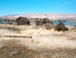 |
Indian Shaker Church |
| |
|
|
Indian Shaker Church (1875)
Built by Henry Gulick, a Scottish immigrant who settled in the area in the 1890s. His wife Harriet, a local Wasco woman, was a member of the Indian Shaker movement, a unique mix of traditional and indigenous spiritual practices. The roof collapsed under snow in November 1996. North of the Shilo Inn, Jct. I-84 and U.S. 197, The Dalles. You can walk to the river side of the Shilo to view, but the buildings are not safe to enter. View from the exterior only.
|
 |
Columbia Gorge Community College |
|
Columbia Gorge Community College (1929)
400 E. Scenic Dr.
(541) 506-6000
Originally built as a 270-bed hospital for tuberculosis patients, known as the Eastern Oregon Tuberculosis Hospital. In May, 1959 the state converted the hospital to the Columbia Park State Home: Oregon’s first institution for chronically ill and geriatric patients. In 1965 it was renamed the Columbia Park Hospital and Training Center; its role was changed to the care of mentally retarded adults. The facility closed in 1977, then sold to Judson Baptist College in the early 1980s. In 1993 it was sold to Columbia Gorge Community College.
|
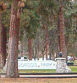 |
Sorosis Park |
 |
Veterans Memorial
|
|
Sorosis Park & Veterans Memorial
350 E. Scenic Drive. Operated by Wasco County Parks and Rec. (541) 296-9533.
This 15-acre park is the largest in The Dalles, and includes picnic area, playground, rose gardens, tennis court, frisbee golf, and walking trail. The Veteran’s Memorial is on the overlook point. The park was founded by the Sorosis Club, an early-day national women’s group. The local chapter also founded City Park, the Carnegie Library, and saved Fort Dalles Surgeon's Quarters from demolition. Sorosis is from the Greek meaning “a multiple fruit formed from many flowers.” The word "soror" means "sister" in Latin. Located at the summit of Scenic Drive, famed photographer Carlton Watkins referred to this point as "Sunset Hill."
350 E. Scenic Drive. (541) 296-9533.
This 15-acre park is the largest in The Dalles, and includes picnic area, playground, rose gardens, tennis court, frisbee golf course, and walking trail. The Veterans Memorial is on the overlook point.
|
| |
|
| |
|
| |
|
| |
|
 |
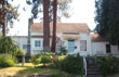
Fulton Taylor House |
| |
|
National Registry of Historic Places |
|
|
Fulton-Taylor House (ca. 1864-1878)
7004 Case Street
The Fulton/Taylor house was built between circa 1864 and 1878, with later additions in the 1920's. Fulton built the front part of the house in the 1870's and platted Fulton's addition from the original 5 acre house lot that he bought from his son in law, HP Issacs. O.D. Taylor was a Baptist minister/real estate developer who implemented the Grand Dalles development on the north side of the river. He lived in the house in the 1890's and performed weddings there. View this home residence from the exterior only.
Download PDF
National Registry of Historic Places
|
|